Remote sensing data enables IWMI researchers to identify irrigated areas at a resolution of 30 meters, providing valuable insights for water policy and agricultural planning
Authors: Kiran M. Chandrasekharan, GIS/RS Specialist at the International Water Management Institute (IWMI); Chandima Subasinghe, GIS/RS Analyst, IWMI; and Amare Haileslassie, Principal Researcher, IWMI
Agriculture is the mainstay of Ethiopia’s economy, accounting for around 85% of the labor force. Yet Ethiopia struggles to feed its population. Irrigation expansion is considered critical for increasing agricultural productivity and addressing food insecurity. But to date only a fraction of the country’s irrigation potential has been realized.
Information about the location and spatial extent of irrigated and rainfed areas is an important requirement for sustainable water resources development and agricultural planning. Currently, considerable variations exist in the irrigated area estimates made by different government agencies. In addition, irrigated area maps created as part of global mapping efforts have a spatial resolution of anywhere between 250 meters and 10 kilometers, making them too coarse for planning and management at a subnational scale.
Using data from satellite sensors, IWMI researchers mapped Ethiopia’s irrigated and rainfed areas at a spatial resolution of 30 meters. Spatial resolution refers to the area on the ground represented by a single pixel in the image. In most situations, this is the size of the smallest feature that can be detected in a satellite image. Images with higher resolution offer greater accuracy and more details about a landscape. The mapping results, published this month, estimate that the total area of croplands is 21.8 million hectares (Mha), of which 1.11 Mha are irrigated. This is only around 5% of the estimated total agricultural area, indicating the urgent need for irrigation expansion if the country is to meet its agricultural growth and food security goals.
More accurate mapping of irrigated areas
Previously, IWMI researchers mapped irrigated areas at a continental scale, covering the whole of Asia and Africa at a resolution of 250 meters. This mapping was based on seasonal vegetation trends in agricultural areas. The current analysis used a similar methodology. However, the process was refined to make it suitable for mapping irrigated areas at the country and even local level, providing more accurate and reliable data than was previously available.
The seasonal trends showed that changes in vegetation and moisture levels in rainfed areas are closely linked to the rainy season, whereas changes in irrigated areas show less correspondence with the rainy season. This was to be expected since irrigated areas do not depend directly on rainfall patterns. As such, the identification of irrigated areas was achieved by analyzing seasonal trends in irrigated and rainfed areas.
The analysis was carried out in two stages. As an initial step, an agricultural area map was developed to exclude non-agricultural areas from the analysis using satellite data archives and classification procedures available in Google Earth Engine. Non-agricultural areas such as hamlets, smaller grasslands, and wetlands are often misclassified as agricultural land in coarse-resolution maps, which can eventually lead to large-scale overestimation of irrigated areas
As part of the analysis, the agricultural areas identified in the first stage were then classified as irrigated or rainfed. This was done using open access satellite images taken at regular intervals over a period of one year in 2015-2016, along with rainfall data sets and field data. The accuracy of the results was evaluated using geographic coordinates of irrigated areas provided by the Ethiopian Ministry of Agriculture. The results confirmed that irrigated areas can be identified reasonably well by analyzing seasonal trends in vegetation and moisture levels.
Valuable data for water policy and irrigation investments
The map subsequently produced shows agricultural areas for the entire country, classified into irrigated and rainfed categories at a resolution not previously available (Figure 1).
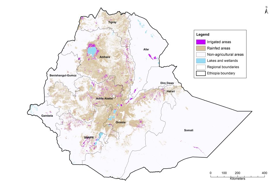
Based on this classification, the map makes it clear that all of Ethiopia’s regional states, except Afar and Gambela, have less than 10% of croplands under irrigation. This dependency on rainfed farming makes food security highly vulnerable to rainfall variability.
Going forward, further work on irrigation suitability – particularly solar irrigation, which IWMI has identified as having high potential for smallholder farmers – combined with the results of this mapping study can provide valuable data-driven information for policymakers, decision makers, and investors about future irrigation expansion in Ethiopia.


